• Home
  • About
  • Destinations
    • South Korea
    • Pakistan
    • United Kingdom
    • Greece
    • Sri Lanka
    • Cambodia
    • Lao PDR
    • Turkey
    • United States
    • Canada
    • Philippines
    • Australia
  • Blog
  • Travel Guides
  • Walking Tours
  • Contact
facebook twitter instagram Email Trending contact
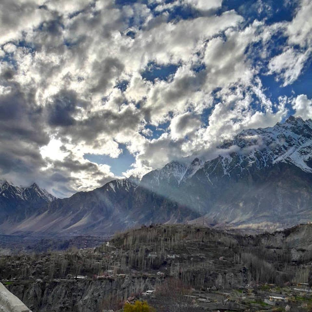
Once you have had enough of Karimabad, you can travel one hour north, and find yourself on the Karakorum Highway leading up to China. This part of Hunza is in fact known as Gojal valley.
The first sight you will see is Attabad Lake. The lake was just formed back in 2010, when a massive landslide buried a 20 km stretch of the Karakoram Highway. You can find boats along the lake, that shuttle people and cars across.


Once you have left Attabad, you will find yourself in Upper Hunza, where the dialect is closer to Wakhi, spoken also in Xinjiang. The first main city you will reach is Gulmit, which is a historic town. It's not as developed as Karimabad, but you will be able to find some small stores here. Beyond Gulmit, you will pass Shishket, which has a small lake there as well. Continue onwards towards Passu, where you will get to see Passu glacier. There's not much there to do, except stare at gigantic mountain ranges that are barren and desert looking, but magnificent.


The last town before you can pass the checkpost to China is Sost. It isn't really populated, but is an important place on the highway for all passenger and cargo transport ; the Pakistani imigration and customs departments are based here.


There aren't many activities throughout the Gojal part of Hunza, so you can instead spend around 1-2 days wandering around the villages.
Share
Tweet
Pin
Share
No comments
Just two hours from Gilgit is Hunza Valley. The Hunza Valley used to be a princely state until Bhutto dissolved that status. It is next to Xinjiang, in China, and is heavily influenced by the proximity to the Chinese border. I visited it in 2008, and again just last week, and can only attest to its beauty. The best way to get there is to fly to Gilgit, and then take a jeep or rented car/van to Hunza. You might get dropped you off in Aliabad, which is the main town in Hunza Valley. It has ATMS and major banks. Then, take another car to get to Karimabad, which is another 15-20 min drive.


Within Hunza, the main city is Karimabad, which overlooks Aliabad and the whole valley. Karimabad has some excellent 4 and 5 star hotels at ridiculously low prices (The Serena Hotel is Rs 6500/night). In Karimabad, you can also check out the musical instruments store, and dried fruit stores. Karimabad is located on the west bank of th Hunza River, and used to be a place for caravans traveling through the Hindu Kush to Kashmir, to rest. You can see the Hunza Peak, the pointed and narrow Lady Fingers peak, and Rakaposhi as well.  In March, there is Cherry Blossom season in Karimabad.


Some distance away is the Baltit Fort, named after Baltit, which used to be Karimabad. 

To its opposite direction is the Altit Fort, named after the town, Altit. The Altit Fort itself is quite majestic, and  was originally home to the hereditary rulers of the Hunza state who carried the title of Mir. Altit Fort is around 1100 years old, which makes it one of the oldest monuments in the area. The Agha Khan Foundation has done some considerable reconstruction work as well.

If you go near the river, you will pass another old settlement, known as Ganish Village. This is known to be one of the oldest and first settlements on the ancient Silk Route, and is the site of various ancient towers, temples and and a reservoir. 
The people of Hunza are one of the most open-minded you will find in Pakistan. They happen to be progressive, and its common to find women walking alone in the valleys. The people there are extremely friendly and welcoming, you will get excellent walnut cake and they even make their own wheat beer and apricot wines!


Share
Tweet
Pin
Share
No comments
Deosai Plains are one of the most well-known tourist destinations up north. The plains are in fact, a plateau and the entire area is known as the Deosai National Park. The park is at an average elevation of 13,500 feet above sea level, making it the second highest plateau in the world, after the Tibetan Plateau.

Deosai is the combination of two words ‘Deo’ (giant) and ‘Sai’ (shadow). For centuries, it is believed that this place is haunted by giants, thus the name ‘The Land of the Giants’ came into being. 

One of the most astounding things of these plains is that it is completely silent and almost cut off from civilization, which is a rarity in populated Pakistan. This area remained unhabitable and remote for a long while, likely due to the temperamental weather and the abundance of wildlife.  

The best time to visit is in the summer or early fall, because between November and May - Deosai is snow-bound and hence, closed for you and me.

There are a number of organized tours that go to Deosai nowadays. Back when I went. which is when I was a wee little girl, that was not the case and Deosai was a tad bit difficult to reach. Fortunately, that is not the case anymore.

In the summer months, it is accessible from Skardu in the north and the Astore Valley in the west. If coming from Skardu, a road from Skardu Bazaar turns to the Sadpara village. If you continue onwards, you'll make your way to the plains.


Legend has it that when Herodotus was reporting the story of 'Gold-digging ants', it was in fact based on the golden Himalayan Marmot, which are small squirrel like creatures, and the habit of local tribes such as Minaro to collect the gold dust excavated from their burrows. No one knows if there is any truth to this.

There is a lot to see here and nearby. The Sheosar Lake is in the park and offers a panoramic view of Deosai Plains with the mountains as a backdrop! Sheosar in local language means ‘andhi’ (blind). This lake is one of the highest lakes in the world, and with deep blue water.

You'll get to see very unique flora and fauna, including the golden marmots. The Himalayan brown bear also lives in these plains. Other animals that call the Deosai Plains their home include the Siberian ibex, Snow Leopard, Kashmir Musk Deer, Himalayan wolf, and many migratory birds. 

There are also lots of flowers, so the plains are not as plain as they may sound.  The locals are friendly and kind so definitely say hi!  
Share
Tweet
Pin
Share
1 comments

I have been fortunate to experience the drive through the Karakoram highway. The Karakoram (the 'crumbling rock' in Turkish language) is quite an incredible engineering feat, mostly because building and maintaining a paved road through such a difficult terrain seems next to impossible. Of course, many people eventually DID die while constructing it.... so that makes me sad.

When you drive on the highway, you definitely encounter a wealth of diversity. Chinese, Turkish, Kurdish, and Greek travelers are common - and its not surprising since the highway has historically had great strategic importance. Historically speaking, this was a caravan trail, one branch of the ancient Silk Road.

Make sure to take note of the landscape, which is quite formidable - the high mountain peaks, deep gorges and torrential Indus running along the track with its full might. More recently, the Chinese and Pakistani governments have built a highway.It is the highest border crossing in the world, over 4800 meters (roughly 16,000 feet) in the Khunjerab Pass at the border.

Here are some particulars and numbers. The highway is around 1300 kilometres (800 miles), and begins in a place called Hassan Abdal, which is near to Islamabad. It goes through Abbottabad, a place where military generals live (and which garnered widespread fame after OBL was found there). The highway then passes through Mansehra, crosses the River Indus at Thakot, on to Gilgit (through Besham, Pattan and Sazin) and then to Chilas, Hunza and Sost before crossing the Khunjerab Pass at the height of some 4800 metres (15,750ft) - the Zero Point between Pakistan and China. It then enters the high Central Asian plateau before winding down through the Pamirs to Kashgar, at the western edge of the Taklamakan Desert.


Some tips about traveling on this highway.
If you are travelling by a car, my advice to you is that you must have a SURPLUS supply of water and fuel with you. Chances are that your car will heat up and the fuel will run out. No jokes, you will have to drive miles before you see any signs of civilization and even then, you won't be sure if the "amenities" they will have will include water and fuel. We ran out on both.

Secondly, on the way you might want to stop by at a few places such as Chilas (which I called Hot-ass) since we went in summer when temperatures were 40 C and above, and no air-conditioning (or electricity for fans). So my advice is to go at a better cooler time around February. However, you can choose to stop at cooler places, further up north but that would be a long non-stop trip. The thing you must know is that although the altitude of KKH gives the impression of it being reasonably cool in temperature, it also crosses the desert (Kohistan I believe) so be prepared for desert-like conditions.

To relieve yourself, you will not find bushes, but rocks. That being said, rocks are a good alternative compared to the holes offered at the towns. There is a lot of rock. Landslides happen. Travel in the day, even if it is hot. The area is desolate and if travelling alone (which I highly advise against), then you can get pretty depressed
Sights you see on the way:
  • Settlements and cities including Bahrain and Madyan (strangely these were cities in the Middle East
  • Glaciers, big ones
  • Mountains, really big ones
  • Crazy drivers with homicidal tendencies
Share
Tweet
Pin
Share
No comments
The Galiat refers to the region roughly 50–80 km north-east of Islamabad, Pakistan, on both sides of the Khyber Pakhtunkhwa-Punjab border. The places that are a part of the Galiat include Ayubia, Bara Gali , Bhurban, Changla Gali, Charra Pani, Dunga Gali, Ghora Gali, Khaira Gali, Khanspur, Murree, Nathia Gali and Thandiani.

Murree is the largest city of the Galiat region, and now perhaps the dirtiest. It is a very popular hill station and a summer resort, especially for Punjabis. Ayubia is a smaller town, near the Murree hills and home to Ayubia National Park. It is a very famous tourist destination and includes one of the oldest chair lifts of the area. However, for places to stay, I would suggest Bhurban, which is around 13 kilometres from Murree city. The Pearl Continental Bhurban is beautiful, and has a large Christmas tree!

Nathiagali is a beautiful hill station, but not at all "awami" (for the locals). It is, I daresay, probably the most elitist in that it serves as the holiday hermitage of distinguished families in Pakistan. Some of the artists also lived there. That being said, it is one of the cleanest and pedestrian-friendly of the Galiats, with no less fear of being harassed or catcalled. There is a lot to see and do in Nathia, so I have an additional post on it.

Sights to see and things to do!

1. Monkeys-- take some crackers to feed them and make some cute videos

2. Ayubia Chairlift

3. The Greens, just because someone you know will be staying there

4. PC Bhurban, and have the Tutti Fruiti Ice cream

5. The Pipeline walk
Share
Tweet
Pin
Share
4 comments
Gilgit was a tad bit overrated (perhaps since I had just visited it after I was at Nanga Parbat base camp). But still, as a popular tourist destination, it still hasn't become touristy. It is also the capital of Gilgit-Baltistan, which is a self-governing territory in the north of Pakistan. Its ancient name was Sargin, later called Gilit. Locals still call it Gilit or Sargin-Gilit.

Unlike most of the capitals of Pakistan that have been destroyed by pollution, over-population, terrorism or crime, Gilgit is one exception. This little city is still continues to have spectacular scenic beauty. The Gilgit Valley lies at an elevation of some 1500 metres and is only 10 kilometres (6.2 miles) off the Karakoram Highway.

The weather is not to my liking. When we visited in July, Gilgit was quite hot (35 degrees Celsius). Given the heat, we didn't stay too long in Gilgit to explore it and do any justice. What is special about Gilgit is that it is the starting point for the journeys that you will make further north or south. We saw it as the end point, but for most tourists, you can fly from Islamabad to Gilgit and drive south to visit Astore, Deosai, Fairy Meadows or whichever place you like.


We took a jeep ride to Naltar Valley where I took lots of photos of donkeys and a snow leopard that was being taken to Nat Geo in the US. I also got to eat fresh prunes there, not the dried ones. Of course, the only downside to Naltar was that by being so accessible and close to Gilgit, it was populated by tourists, who had trashed some of the places with there food.


SIGHTS TO SEE: 
  • Buddha Carvings- Two miles out of town there are a pair of Buddha's carved in to a high rock. They date back to the 5th century and are a historian's dream.
  • Yes, adventure-lover, Rakaposhi base camp. Base camps are for people like me who love the adventure of hiking and feel that by reaching a base camp, have accomplished some feat. I would like to climb a mountain too some day, but not sure exactly when.  
  • Naltar Valley with the lake and the big peaks around it. Magnifico!  
  • Hunza is close by too! From there you can go anywhere. Skardu, Astore, Rama, you name it!  
  • Laila Peak in Haramosh Valley (east of Gilgit). Now, wait a minute people. There are three Laila Peaks in Pakistan: Laila Peak (6096 or 6614m) in Hushe Valley, Karakoram, Laila Peak(6985m) in Haramosh Valley, Karakoram (near Chogurunma Glacier) and Laila Peak (5971m) in Rupal Valley, Himalaya. In case you don't know, my name is Laila.


Share
Tweet
Pin
Share
No comments
While you are on the Karakoram highway, you might as well see these two places, that should definitely be on your bucket list. After passing the exit for Fairy Meadows, keep driving for about another 20 minutes. When you come across the sign for Astore, turn right, keep going for another 2-3 hours. You will arrive at the village of Astore. Astore is the capital of Astore District of Gulgit-Baltistan. It is at an altitude of 2546 metres (8353 feet) and is the coldest place within the country, with temperatures reaching -26 degrees celcius.


From Astore, you should enquire from the locals for directions to Rama Valley. The valley is popular for camping in the summers, and also has a good PTDC hotel. From Astore, you can take a jeep ride to Rama Valley, a forested vale with huge pine, cedar, fir and juniper trees. In summer, the valley becomes lush green with some snowy patches left from the Winter. From here one can trek to east side of the Nanga Parbat (also known as the Killer Mountain), the world's 8th highest mountain. I believe there is a documentary on it.


These places should not be avoided at any cost. You haven't seen the beauty of this world if you haven't been here. However, I went at a time when the road to Rama Lake from the valley wasn't cemented and I have heard that it has been done so now. This only has left me worried, because the large influx of the tourists will destroy the place. 

When I went, I vividly remember the long walk through rock and snow, to reach this untouched lake, so virgin in its beauty. There wasn't any trash lying around as there is in many tourist lakes such as Saif-ul-Malook. The only person I saw was a Pakhtun, saying his prayers on a piece of rock. It was a divine moment, watching the lake, so calm and still and clear. I wanted to stare at it forever. The PTDC Motel at Rama is also one if not the best PTDC Motel in Pakistan. It has standards as high as the Serena, and yet the rates are so nominal that you will be pleasantly surprised.


SIGHTS TO SEE:
  • Lakes on the way to Rama Lake 
  • Rama Lake- exquisitely serene. 
  • Nanga Parbat 
  • Small villages- observing the simple people is interesting since they are so happy with even the barest of necessities 

Share
Tweet
Pin
Share
No comments

About me

Hi everyone! I'm Laila. Welcome to my blog! Here, you'll find stories of me and my family as we explore the world. It's not easy traveling when you often need visas, or you have kids, but we have made travel work for us! Join us, as we make some curious discoveries of history, food and culture while treading on new paths.

300*200
300*250

Follow Galati

  • instagram
  • facebook
  • medium
  • linkedin
  • Twitter
  • YouTube
300*250

Popular posts

Top Non-White Travel Blogs to Follow

Created with by ThemeXpose | Distributed by Blogger Templates

All images on this website are under a creative commons licence.
© Galati Travels 2021. All rights reserved. Read our Privacy Policy.